Questions
Is this a real proposal?
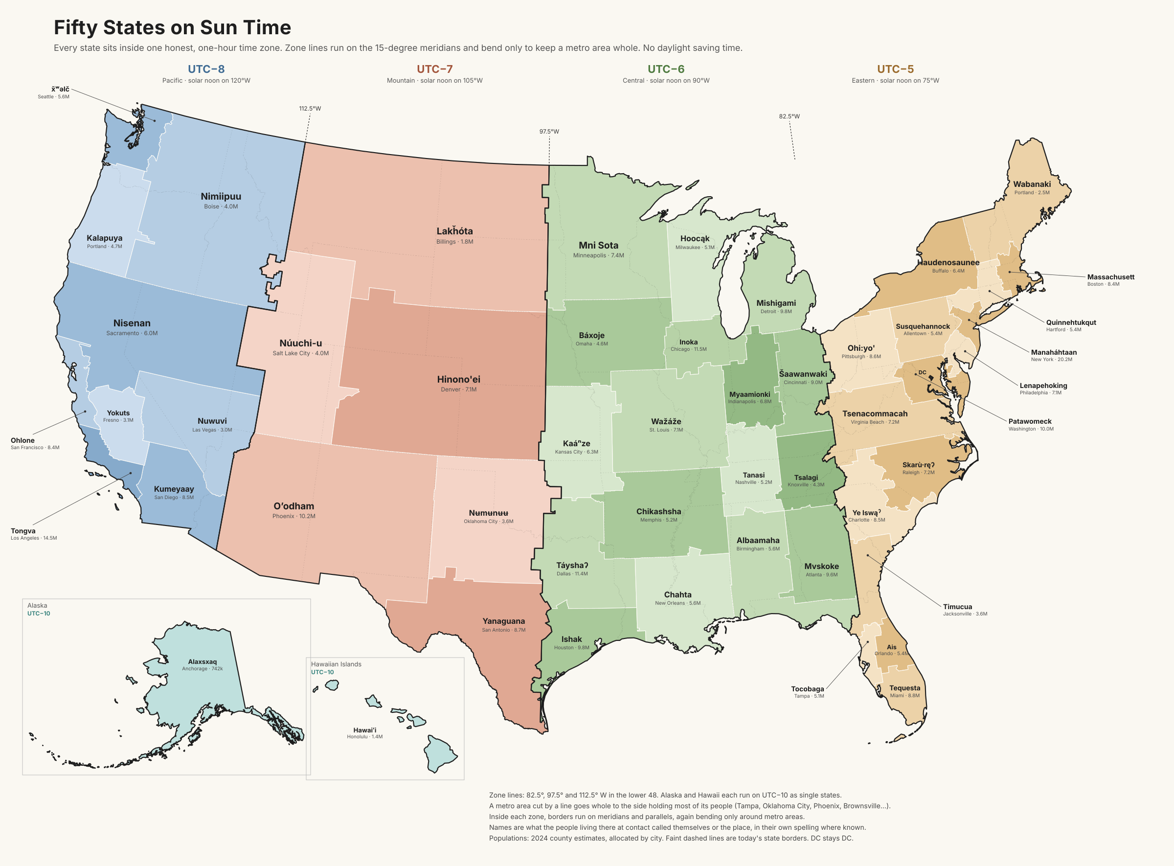
No. Nobody is going to redraw fifty states, and we're not asking anyone to. The map is a way to look at where the zone lines should sit and whose names are on the land. It also takes a side on the clock change, which is in front of Congress right now.
Why not half-hour zones? They'd match the sun even better.
They would, and a few countries use them. But every half-hour zone doubles the number of clocks a person has to keep track of, and the gain is small. With one-hour zones drawn honestly, nobody in the lower 48 is more than about half an hour off the sun. That's close enough.
Doesn't permanent standard time mean dark summer evenings?
Earlier ones, not dark ones. In Chicago in late June the sun would set around 7:30 instead of 8:30. It would also rise around 4:15, which is the part people notice less. We think bright winter mornings are worth more than the extra summer hour, and so do the sleep researchers. It's a fair thing to disagree about.
Why is Austin in a different zone from Dallas?
Because Austin is almost entirely west of 97.5° and Dallas is almost entirely east of it. Austin's clock today runs about half an hour ahead of the sun in winter and an hour and a half ahead in summer. On this map it's half an hour behind, all year.
What happens to Arizona?
Most of it lands in Oʼodham, on UTC−7 all year, which is what Arizona already does. The difference is that New Mexico and El Paso join it.
Why are some states so much bigger than others?
We didn't balance population on purpose. The New York metro area alone is about 20 million people, and the map never splits a metro area, so that state was always going to be big. The northern plains have very few people across a lot of ground. The range on this map is still narrower than the current one.
What about the Senate?
Every state still gets two senators, so the Senate would look very different. We haven't tried to work out how, and we're not going to. That's a different website.
What about DC and the territories?
DC stays DC. Puerto Rico, Guam, the US Virgin Islands, American Samoa and the Northern Mariana Islands aren't on the map. Most of them already skip daylight saving time.
Who decided the names?
We did, using the rule on the names page, and we'll change any of them if the people they belong to tell us something better. We don't speak for any nation on the map.
Can I use the map?
Yes. Credit sunstandardtime.org and link back. The full-size map is here as a PNG and an SVG.